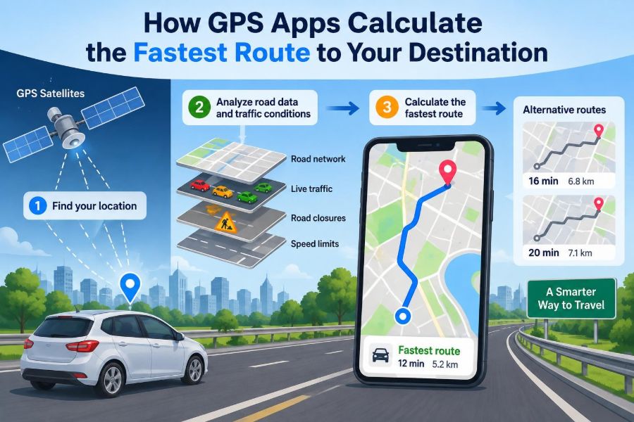

You leave work just as rain begins to slow traffic. Your navigation app offers two routes: one is shorter on the map, while the other arrives sooner. It may even change its recommendation halfway through the drive.
That decision looks simple on a phone screen, but it depends on location measurements, detailed map data, live observations, mathematical models, and powerful search algorithms. A GPS app must make a useful prediction before road conditions change again.
The phrase “fastest route” can be misleading. It rarely means the route with the fewest kilometres or the fewest turns. It means the route the app currently predicts will take the least time under selected rules and likely conditions.
Understanding this process makes navigation tools less mysterious. It also explains why an app sometimes reroutes you, asks about a toll road, or chooses an unexpected side street. 🗺️
📍 1. A GPS App Combines Several Technologies
People often call every navigation app a “GPS,” but GPS is only one part of the system. GPS helps determine where you are; digital maps and routing software decide how to travel from your current position to a destination.
A typical app combines a positioning receiver, map database, network connection, route-search algorithm, traffic model, and user settings. Each part contributes a different answer to the overall navigation question.
- Where am I now?
- Which roads or paths are available?
- How long will each option probably take?
- Which option best matches my preferences?
🛰️ 2. GPS Finds a Position Using Satellites
The Global Positioning System uses satellites that broadcast signals containing timing and orbital information. A receiver compares the time a signal was sent with the time it was received to estimate its distance from each satellite.
Using measurements from multiple satellites, the device estimates a position on Earth. This process is commonly called trilateration: the receiver finds the point consistent with several measured distances.
Modern phones may also use other satellite constellations, depending on their hardware and region. More usable signals can improve availability, especially when part of the sky is blocked.
⏱️ 3. Timing Accuracy Is Essential
Radio signals travel extremely quickly, so a very small timing error can create a meaningful error in the estimated distance. Satellite navigation systems therefore depend on highly accurate clocks and careful corrections.
Your phone does not need an atomic clock of its own. Instead, it uses signals from enough satellites to solve for both its location and an error in its internal clock.
This is why satellite positioning is a measurement problem, not simply a device “seeing” a dot from space.
🏙️ 4. Your Blue Dot Is an Estimate, Not a Guarantee
Buildings, trees, tunnels, weather conditions, signal reflections, and limited satellite visibility can affect positioning. In a dense city, a signal may bounce off a building before reaching the phone, making it appear to have travelled farther.
Apps often blend satellite readings with Wi-Fi information, mobile-network data, motion sensors, and previous positions. This can make the displayed location more stable when raw GPS measurements are noisy.
The blue dot may have an accuracy circle around it. A larger circle means the app is less certain about the exact position.
🧩 5. The App Matches Your Position to a Road
A location estimate is a coordinate, but routes are built from roads. If your dot appears near several parallel roads, the app must infer which one you are actually using.
This process is called map matching. The app considers proximity, your direction of movement, speed, nearby road shapes, and recent positions rather than blindly choosing the closest line.
Map matching explains why an app can usually keep your marker on a road even when the measured position wiggles slightly beside it.
🗂️ 6. Digital Maps Store More Than Road Shapes
A navigation map is not just a picture of streets. It is a structured database containing geometry and attributes that software can search and interpret.
For a road segment, the data may include its length, direction of travel, speed information, road class, name, restrictions, and connections to other segments. The details needed vary for driving, walking, cycling, and public transport.
- One-way streets and divided carriageways
- Turn restrictions at intersections
- Toll roads, ferries, bridges, and tunnels
- Pedestrian paths, stairs, or cycle lanes
- Temporary or permanent closures when available
🕸️ 7. Roads Become a Graph
To calculate routes efficiently, the app represents the transport network as a graph. A graph is a mathematical structure made of nodes and edges.
In a simplified road graph, intersections are nodes and road sections are edges. An edge connects one point to another and has properties such as distance, allowed direction, and estimated travel time.
This representation turns “How do I get there?” into a well-studied computer science problem: finding a good path through a connected network.
➡️ 8. Direction Rules Change the Graph
Many roads cannot be used equally in both directions. A one-way street creates a directed edge: travel may be possible from A to B but not from B to A.
Turn rules matter too. A route may reach an intersection but still be unable to make a left turn, enter a restricted lane, or cross a median.
Accurate routing must model these rules. Otherwise, an algorithm could suggest a route that looks connected on a map but is illegal or impossible to drive.
⚖️ 9. Every Road Segment Receives a Cost
Routing algorithms compare choices by assigning a cost to each edge. For a fastest-route search, the main cost is usually estimated travel time.
A simple starting model is travel time equals distance divided by expected speed. Real systems refine this with intersection delays, turns, road conditions, and expected congestion.
estimated time = road length / expected travel speed
The algorithm adds segment costs to estimate the total cost of a complete route. Lower total cost generally means a more attractive route.
📏 10. The Shortest Route Is Not Always the Fastest
Distance and time are different objectives. A short route through slow streets, busy intersections, and traffic lights may take longer than a longer route on a free-flowing road.
| Route characteristic | Effect on distance | Possible effect on travel time |
|---|---|---|
| Direct city streets | Often shorter | Can be slower because of stops and congestion |
| Motorway or expressway | Often longer | Can be faster at sustained speeds |
| Toll route | May vary | May save time, depending on conditions |
| Scenic or local road | May vary | May be slower but preferred for other reasons |
When an app says “fastest,” it is optimizing its current time estimate, not necessarily minimizing fuel use, simplicity, safety, or enjoyment.
🚦 11. Intersections Have a Time Cost Too
Road length alone cannot describe urban travel. Waiting at traffic lights, yielding, turning across traffic, and navigating complex junctions can consume substantial time.
Routing models may include expected delays for intersections and turns. A left turn in a busy area, for example, can be treated differently from continuing straight ahead.
This is one reason two roads with similar lengths and posted speed limits can receive very different travel-time estimates.
📡 12. Live Traffic Updates Improve Predictions
Many apps receive traffic information from a mixture of sources. These can include aggregated movement data from participating devices, road operators, incident reports, and historical observations.
The system looks for patterns such as many vehicles moving unusually slowly along a particular road segment. It can then increase that segment’s predicted travel time.
Traffic data is typically used in aggregated forms for routing analysis rather than as a public display of an individual person’s journey.
📈 13. Historical Traffic Fills in Missing Information
Live traffic is useful, but it is not available equally on every road or at every moment. Historical patterns help estimate conditions when recent observations are limited.
A road may usually move differently during a weekday morning, a weekend evening, or after a major event. The app can use these patterns as part of its forecast.
Historical data describes what often happened before, not what must happen today. A crash, weather change, or roadworks can make normal patterns unreliable.
🔮 14. A Route Is a Prediction About the Future
Navigation is harder than measuring current speeds. A long route may reach its final roads much later, so the app must estimate what conditions will be when you get there.
This is often called time-dependent routing. The travel time for an edge can depend on the time at which the route enters that edge.
For example, a road that is moving freely now may be expected to become busy by the time you approach it. ⌛
🔍 15. The Algorithm Searches Without Trying Every Route
A city can contain an enormous number of possible paths between two points. Testing every possible route would be impractical, especially when a phone must respond quickly.
Instead, algorithms systematically explore promising options while keeping track of the best known cost to reach each part of the network. Paths that are already clearly worse can often be ignored.
This reduces a seemingly overwhelming search into a manageable calculation.
🧮 16. Dijkstra’s Algorithm Finds Lowest-Cost Paths
Dijkstra’s algorithm is a foundational shortest-path algorithm. It repeatedly selects the unvisited location with the lowest currently known total cost from the starting point, then updates nearby possibilities.
If all edge costs are non-negative, the algorithm can determine a least-cost route through the graph. In routing, “cost” can mean time, distance, money, or a combined score.
Basic Dijkstra searches can be expensive on very large networks, so practical navigation systems use additional optimizations.
🎯 17. A* Uses a Smart Estimate to Guide the Search
The A* algorithm improves on a broad search by using a heuristic: an estimate of the remaining cost to the destination. Straight-line distance is a common starting idea for such an estimate.
A* balances two values: the cost already spent reaching a point and the estimated cost still needed. This encourages the search to move generally toward the destination.
When designed carefully, the heuristic speeds up searching without sacrificing the ability to find an optimal route under the chosen cost model.
⚡ 18. Large Services Preprocess Their Road Networks
Major navigation services often do more than run a fresh basic search across every road for every request. They can preprocess map networks and organize them into structures that make long-distance queries faster.
One useful idea is that important roads form a hierarchy. A cross-country trip is likely to use major roads for much of its length, while small local streets matter most near the start and finish.
Preprocessing helps systems answer quickly, but current traffic, incidents, and user preferences still require route-specific calculations.
🛣️ 19. Road Hierarchies Reduce Unnecessary Detail
A neighborhood street, an arterial road, and a motorway play different roles in a network. Routing engines may use this structure to focus early search effort where it is most likely to matter.
For a long journey, the engine can seek efficient connections to higher-level roads, travel across the wider network, then return to local detail near the destination.
This is an optimization technique, not a rule that major roads are always best. Heavy traffic or restrictions can make local alternatives more attractive.
🔄 20. Rerouting Is a New Search Problem
When you miss a turn or traffic changes, the app does not merely redraw a line. It updates the start position, available road conditions, and sometimes the estimated costs throughout the network.
Then it performs a new route search, often using the remaining journey rather than recalculating every detail from scratch. The goal is to react quickly enough to be useful.
Frequent rerouting can be frustrating, so apps may also avoid changing a route for a tiny predicted improvement that could disappear moments later.
🚧 21. Closures and Incidents Can Remove Edges
A confirmed closure changes the graph itself. The affected road segment may become unavailable, meaning the route search cannot use it at all.
An incident that slows traffic does something different: the edge remains available, but its time cost rises. The algorithm may still choose it if every alternative is worse.
Data quality matters here. A report can be outdated, incomplete, or applicable only to one direction of travel.
⚙️ 22. Your Settings Change What “Best” Means
Navigation apps usually provide choices such as avoiding tolls, motorways, ferries, or unpaved roads. These options alter which edges are allowed or how costly they appear to the routing engine.
For example, avoiding tolls may exclude toll segments entirely or strongly penalize them. The resulting route may take more time because the app is solving a different optimization problem.
- Fastest: minimize predicted travel time.
- Shortest: minimize distance, when offered.
- Avoid tolls: prefer routes without toll charges.
- Walking or cycling: use a different network and different restrictions.
🚶 23. Different Travel Modes Need Different Maps
A route suitable for a car may be unsuitable for a pedestrian, cyclist, truck, or wheelchair user. Each mode has different legal access, physical constraints, and practical preferences.
Walking routes can use footpaths and crossings unavailable to vehicles. Truck routes may need to account for height, weight, hazardous-material, or road-access restrictions when such data is available.
Good navigation is therefore not one universal route algorithm. It is a collection of related models built for different kinds of travel.
🧠 24. Machine Learning Can Improve Travel-Time Estimates
Machine learning can help estimate travel times from many signals, including road type, time of day, past traffic patterns, weather-related inputs where available, and current movement observations.
It does not replace the road graph or shortest-path algorithms. Instead, it can improve the estimated edge costs that those algorithms use.
The result still depends on the quality of the underlying data. A sophisticated model cannot fully predict a sudden event that has not yet been observed.
⚠️ 25. Fastest Does Not Mean Perfect
Every route recommendation contains uncertainty. Traffic can change after the calculation, a reported closure may be inaccurate, and a driver may encounter conditions that map data cannot represent.
Estimated arrival times should be read as forecasts, not promises. They become more useful when drivers combine them with attention to road signs, local laws, and real-world safety conditions.
Most importantly, a navigation app should support driving decisions, never distract from them. 📵
🔐 26. Location Data Raises Privacy Questions
Route planning requires at least a starting location and destination information, and traffic features may use movement data from devices that participate in those services. This makes privacy controls important.
Users should understand app permissions, account settings, location-history options, and the difference between sharing a live location with someone and using location data for navigation.
Convenience and privacy are not opposite ideas. Informed settings help people decide which features they want to use.
🧭 27. The Core Principle: Find the Lowest Predicted Cost
A GPS app calculates the fastest route by converting roads into a graph, assigning a predicted travel-time cost to possible segments, and searching for a path with the lowest total cost.
Satellite and sensor data help locate the traveller. Map matching places that estimate on the correct road, while live traffic, historical patterns, restrictions, and preferences refine the cost of each possible choice.
The route is not simply drawn on a map; it is the result of an ongoing prediction and optimization process. As your position and road conditions change, the calculation can change too. 🛰️🗺️🧭